


What is the CWH Zone?
The Coastal Western Hemlock Biogeoclimatic zone (or CWH zone) gets its name from the abundance of Western Hemlock present across the Pacific coast region. Western Hemlock is also known as Tsuga heterophylla. This zone is a coastal temperate rainforest with dense conifer forests, relatively few herbs but with abundant mosses. Wind is the most common natural disturbance agent in this zone, creating a patchy mosaic of tree ages. The CWH zone is the rainiest zone in BC, due to moisture coming off of the nearby Pacific Ocean. This abundance of moisture plays a role in the lack of disturbance by fire in this zone, so trees are capable of reaching old ages and large sizes.
Distribution
The CWH zone covers about 10.8 million hectares or 11.4% of the province of British Columbia, but these forests also extend northwards into Alaska and southwards into Washington and Oregon. Within BC, the CWH forests cover much of the low to mid-elevations along the Pacific coast, including Vancouver Island, Haida Gwaii and the Coast Mountains. These forests also extend inwards along the major river valleys of the Fraser and Skeena Rivers. They occupy elevations from sea level to 900 m on windward slopes in the south and sea level up to 300 m in the northern extent of the zone. Above the CWH zone, the ecosystems generally transition into the subalpine forests of the Mountain Hemlock Zone.
Climate
The CWH is, on average, the rainiest ecological zone in Canada, with annual precipitation ranging from 1400 mm to 5000 mm. This zone has mild winters and cooler summers, but hot dry spells are also typical. The mean annual temperature is about 8°C across the zone, but the average monthly temperature is above 10°C for about a third of the year. During the coldest month, the mean temperature is 0.2°C, but ranges from -6.6 to +4.7°C across the subzones.
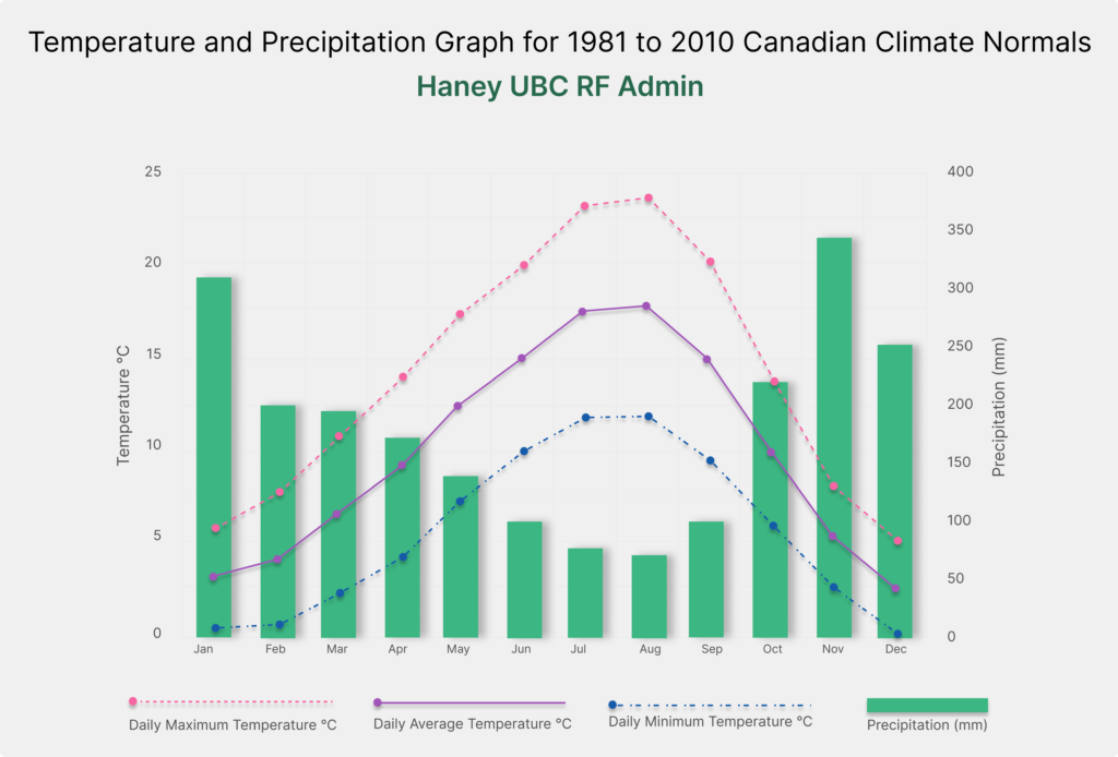
https://climate.weather.gc.ca/climate_normals/index_e.html#1981=0
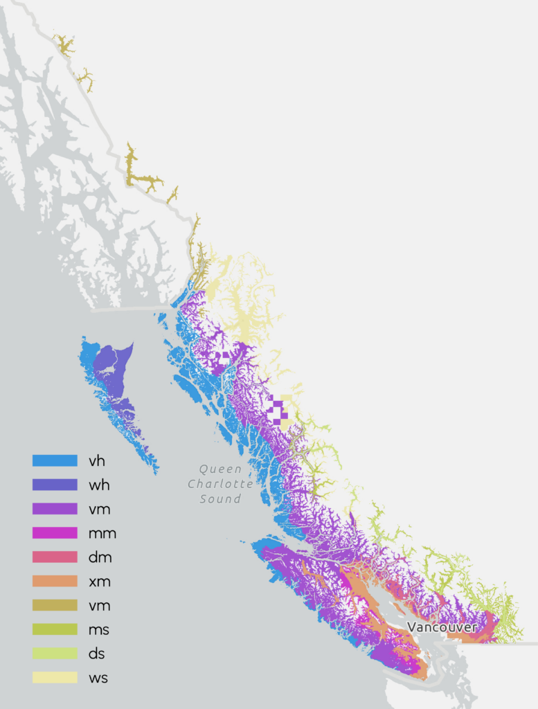
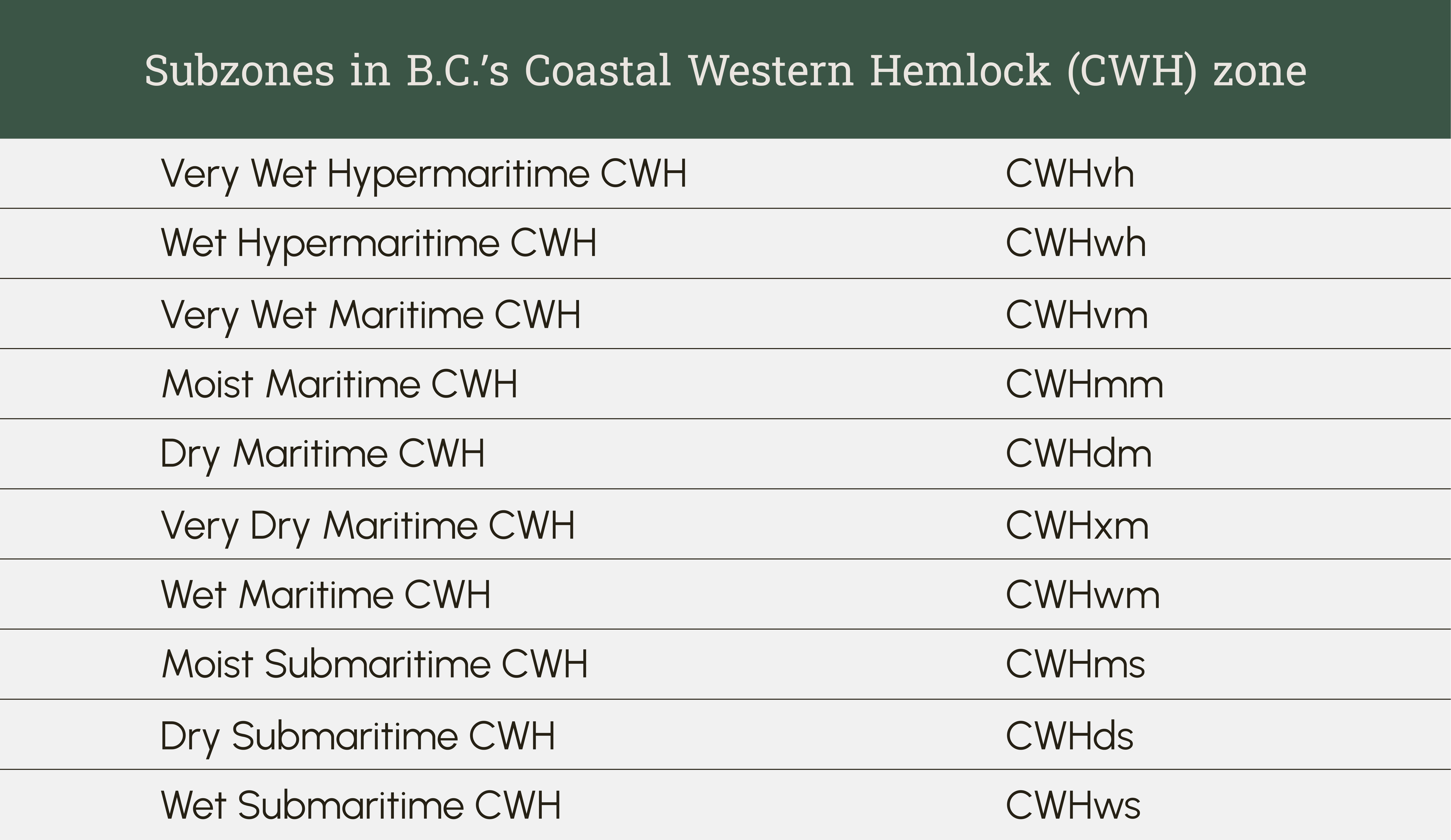
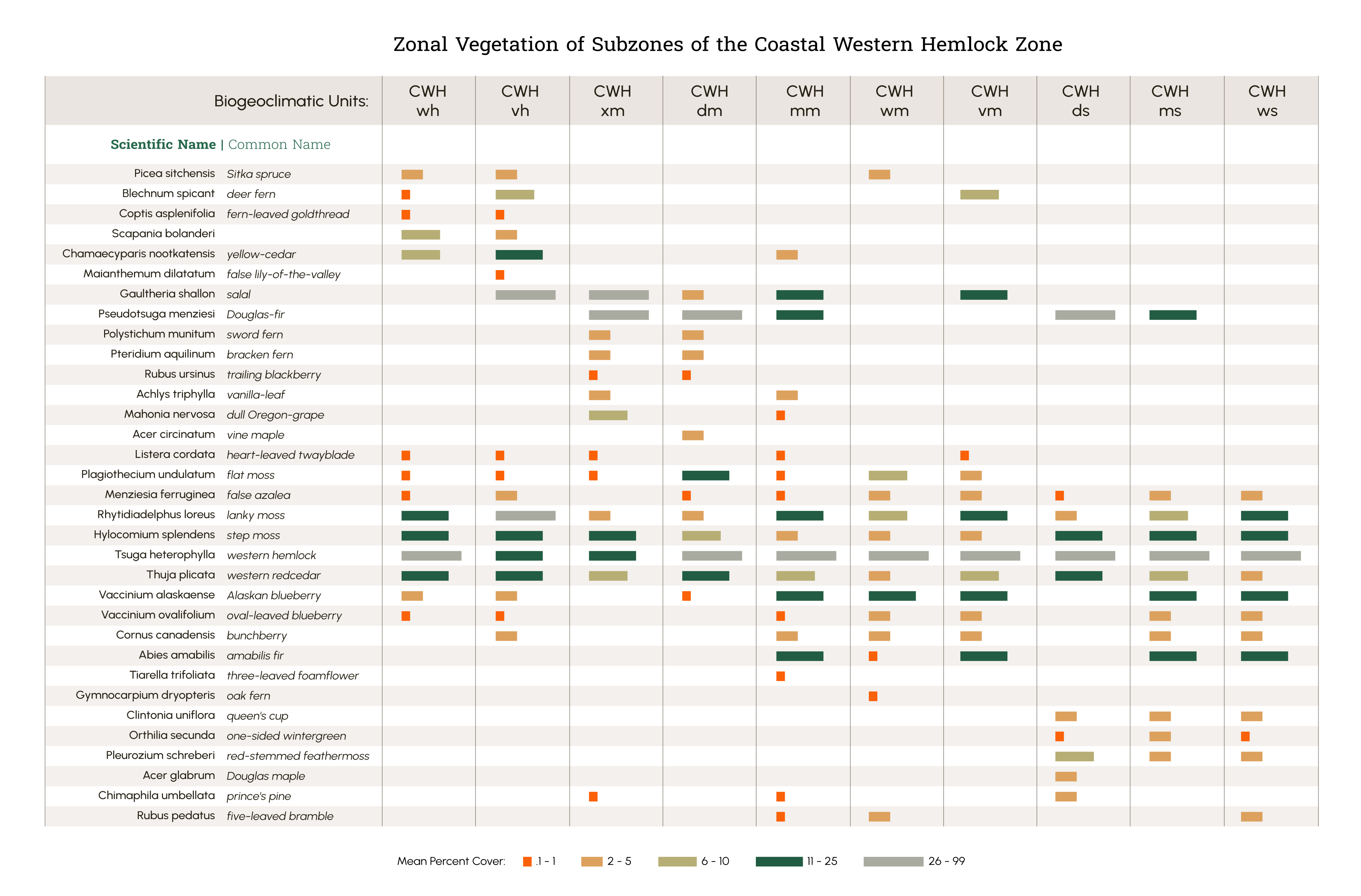
Subzones within the CWH
The climate in the CWH zone is heavily influenced by the Pacific ocean and the mountain ranges in the region. The nearness to the ocean and the level of precipitation resulting from the rainshadow effect creates different conditions which result in slightly different plant communities. These different conditions are distinguished in the 10 subzones of the CWH zone. The nearness to the ocean is described as “continentality”. The areas closest to the ocean, such as the outer west coast of Vancouver Island, are known as hypermaritime, as they are directly exposed to the Pacific. The maritime zone exists in between the hypermartime and submaritime zones, and includes the eastern side of Vancouver island and the Greater Vancouver area. The submaritime subzones occur on the leeward side of the Coast Mountains and are further away from the influence of the Pacific ocean.
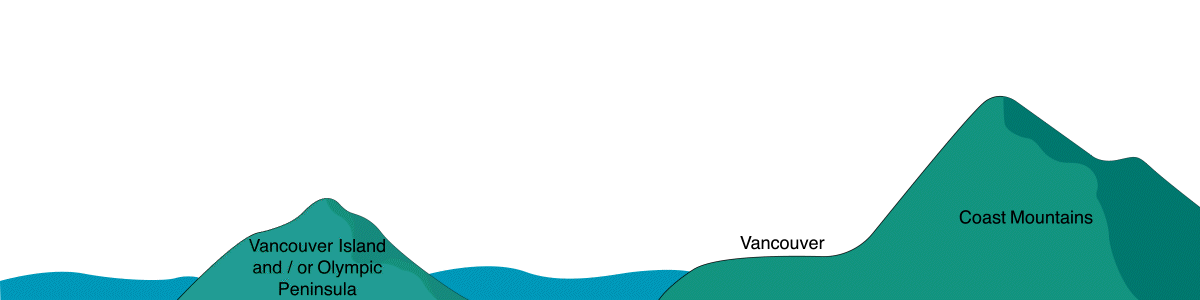
Although the CWH is the rainiest zone in BC, the amount of precipitation varies widely across the subzones. This is due in part to the rain shadow effect. As air moves up in elevation it cools and condenses, which causes it to release its precipitation as it rises up and over a mountain. The lower elevations tend to get less rain, and therefore are relatively drier than the higher elevations on the windward side of a mountain. There is also less moisture released on the leeward side of a mountain, which is why its called the rain shadow effect. There are several mountain ranges across the CWH region including the Olympic Mountains, Vancouver Island Ranges, and Coast Mountains, so the rain shadow effect repeats several times. The result is a high variability of precipitation throughout the CWH zone as air masses move up and over these different mountains. This variability is shown in the subzones as ranging in precipitation levels from very dry, dry, moist, wet, to very wet.
Although Western Hemlock is dominant throughout the zone, the cover of the other major tree species varies with climate across the subzones. Douglas-Fir (Pseudotsuga menziesii) is common in the drier and warmer subzones; Amabilis Fir (Abies amabilis) in the wetter and cooler subzones with higher elevation or latitude; and Yellow Cedar (Callitropsis nootkatensis) in the wetter, hypermaritime and maritime subzones. Local conditions also can determine which species will be present such as shore pine on very dry or wet sites, Red Alder (Alnus rubra) on disturbed sites, and Black Cottonwood (Populus balsamifera ssp. trichocarpa) on floodplains. The climate conditions also are transitional between Biogeoclimatic zones. For example, the driest maritime subzone in the CWH, the CWHxm, has plants such as Douglas-Fir, Grand Fir (Abies grandis), Arbutus (Arbutus menziesii) and Garry Oak (Quercus garryana), so it strongly resembles the nearby Coastal Douglas-Fir (CDF) zone, but has more Western Hemlock than the CDF.
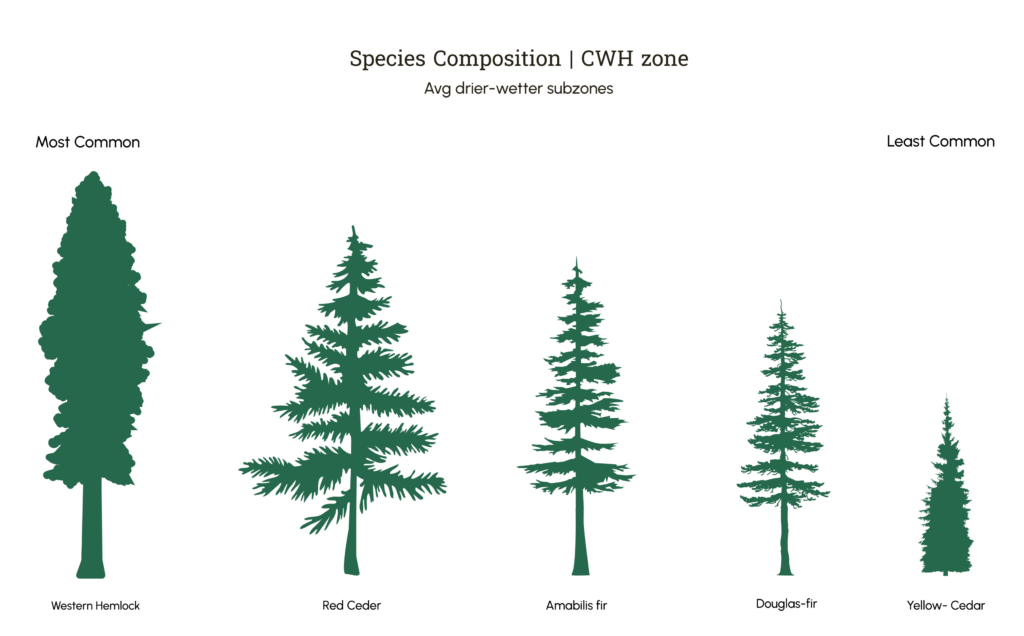
Overall summary of species composition in the CWH zone. To see a more detailed breakdown by subzone visit:
https://cfcg.forestry.ubc.ca/resources/cataloguing-in-situ-genetic-resources/cwh-zone/cw-species-composition/
The bedrock geology in the CWH zone, although variable, is frequently made up of granodiorite rocks. These rocks form the parent material that developed into soils over time through various physical and chemical processes, including the massive forces of glaciation which impacted this region significantly. Granodiorite is a rock that is acidic in nature, low in nutrients and tends to break down into sand sized particles, rather than clay minerals. These factors all result in a soil that tends to be rapidly draining, acidic and low in nutrients. The low nutrient levels also influence the humus forms and soil organisms that are present. Mor humus forms are the most common, where the main decomposers are fungi.
The relatively high level of precipitation in the CWH zone also leads to the action of leaching and deposition within the soil profile. These soil forming processes are known as eluviation and illuviation. Eluviation, which is also known as leaching, occurs when water washes suspended materials from one soil horizon to another. Illuviation occurs when these suspended materials are deposited into a lower horizon. Through these processes Podzolic forest soils develop over time, where iron is moved into a lower horizon and accumulates, becoming a redder, iron rich horizon which is known as a Bf. The upper horizons become stripped of iron, leaving them a paler, greyish colour, known as an Ae horizon. These two horizons are diagnostic horizons of Podzolic forest soils.
Creative Commons License This work is licensed under a Creative Commons Attribution-NonCommercial-ShareAlike 4.0 International License.
The relatively high level of precipitation in the CWH zone, combined with cooler temperatures, leads to accumulations of organic matter on the forest floor. Sometimes in the wettest parts of the CWH zone, these form thick organic layers that can be more than 40cm thick. These thick organic layers change the soil type to be a Folisol , which is a special type of Organic soil. Most Organic soils form in wetlands, but Folisols are the exception to the rule. Soil conditions vary across the zone, but these are some of the typical traits that you will come across in the CWH zone.
Soil of the Folisol Great Group, Central coast of B.C. These soils have thick F (fibric) and H (humic) horizons formed by accumulation of forest floor organic material in wet conditions. Thick tree roots are evident from 60 to 80 cm. © Paul Sanborn is licensed under a CC BY (Attribution) license. Taken from Digging into Canadian Soils.